From the latest satellite images and GIS to early hand-drawn maps, cartography has gone hand-in-hand with conservation at NCCC. It’s all part of knowing the land.
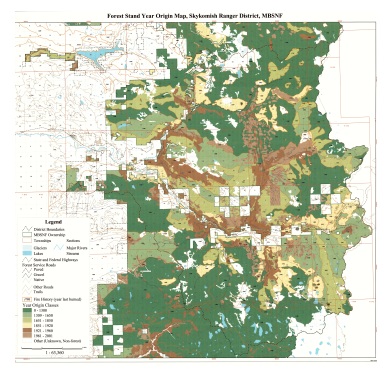
MBS National Forest Stand Age and Fire History Maps
Next time you’re looking for ancient forest remnants on the MBS, these maps will be very useful! Jan Henderson, USFS Ecologist, ret., made extensive surveys of forest stand ages and last fire dates throughout the Mt. Baker Snoqualmie (MBS) National Forest concluding in 2005. With the help of Darrington District Ranger Camden Bruner we were able to have maps made of the Mt. Baker and Darrington RDs in 2025 based on Henderson’s data. Our thanks to Gary Paull, USFS ret., for the Skykomish RD map he produced previously. NCCC interviewed Jan Henderson in 2012, and you can read the interview in which Henderson discusses his work: https://northcascades.org/wp-content/uploads/2025/05/Jan-Henderson-interview.pdf
Below is an example thumbnail image of one of the maps — please use the links below it to access the high-resolution PDFs.
Mt. Baker RD:
https://northcascades.org/wp-content/uploads/2025/05/MBRD-Stand-Age-and-Fire-History-Map.pdf
Darrington RD:
https://northcascades.org/wp-content/uploads/2025/05/DRD-Stand-Age-and-Fire-History-Map.pdf
Skykomish RD:
https://northcascades.org/wp-content/uploads/2025/05/SRD-Stand-Age-and-Fire-History-Map.pdf
Note that on the Skykomish map, numbers are the years of origin of the forest stands, while for the other two maps the forest stands are shown in colored areas keyed in the legends to their “stand age.”
For further reading, here’s a 2009 report on the USFS Pacific Northwest Ecology Program that Mr. Henderson was part of: https://www.fs.usda.gov/Internet/FSE_DOCUMENTS/fseprd1178227.pdf
And here’s the FS’s “Ecoshare” site where the project info is made public: https://www.fs.usda.gov/ecoshare
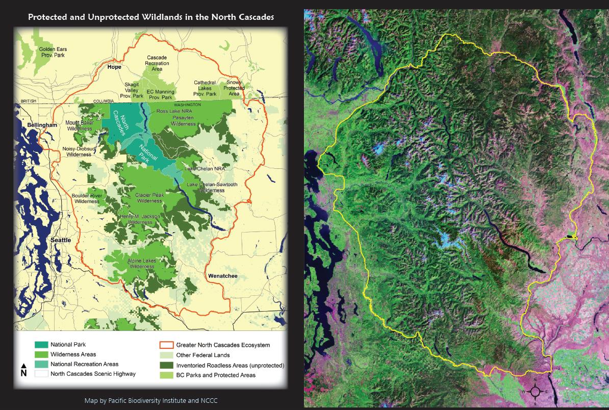
Land Designations and the Ecosystem
Note how much of the greater ecosystem outlined in the satellite view on the right remains unprotected in the designation map on the left (note that the dark green areas in the designation map are roadless but unprotected). These maps can be viewed high-resolution in our brochure.
Geologic Map of the North Cascades
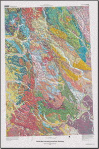
NCCC member Rowland Tabor (1932-2022), author of “Routes and Rocks” and “Mountain Mosaic,” co-authored the USGS geologic map of the North Cascades. Click the thumbnail to the left to visit the USGS website where you can view the map and supplementary materials.
“The North Cascades are generally characterized by exposure of plutonic and metamorphic rocks in contrast to the volcanic terrain to the south. The rocks of the North Cascades are more resistant to erosion, display greater relief, and show evidence of more pronounced uplift and recent glaciation.” More…
(Haugerud, Ralph A., and Tabor, Rowland W., 2009, Geologic map of the North Cascade Range, Washington: U.S. Geological Survey Scientific Investigations Map 2940, 2 sheets, scale 1:200,000; 2 pamphlets, 29 p. and 23 p.)
The Shrinking Glacier Peak Wilderness Area started NCCC
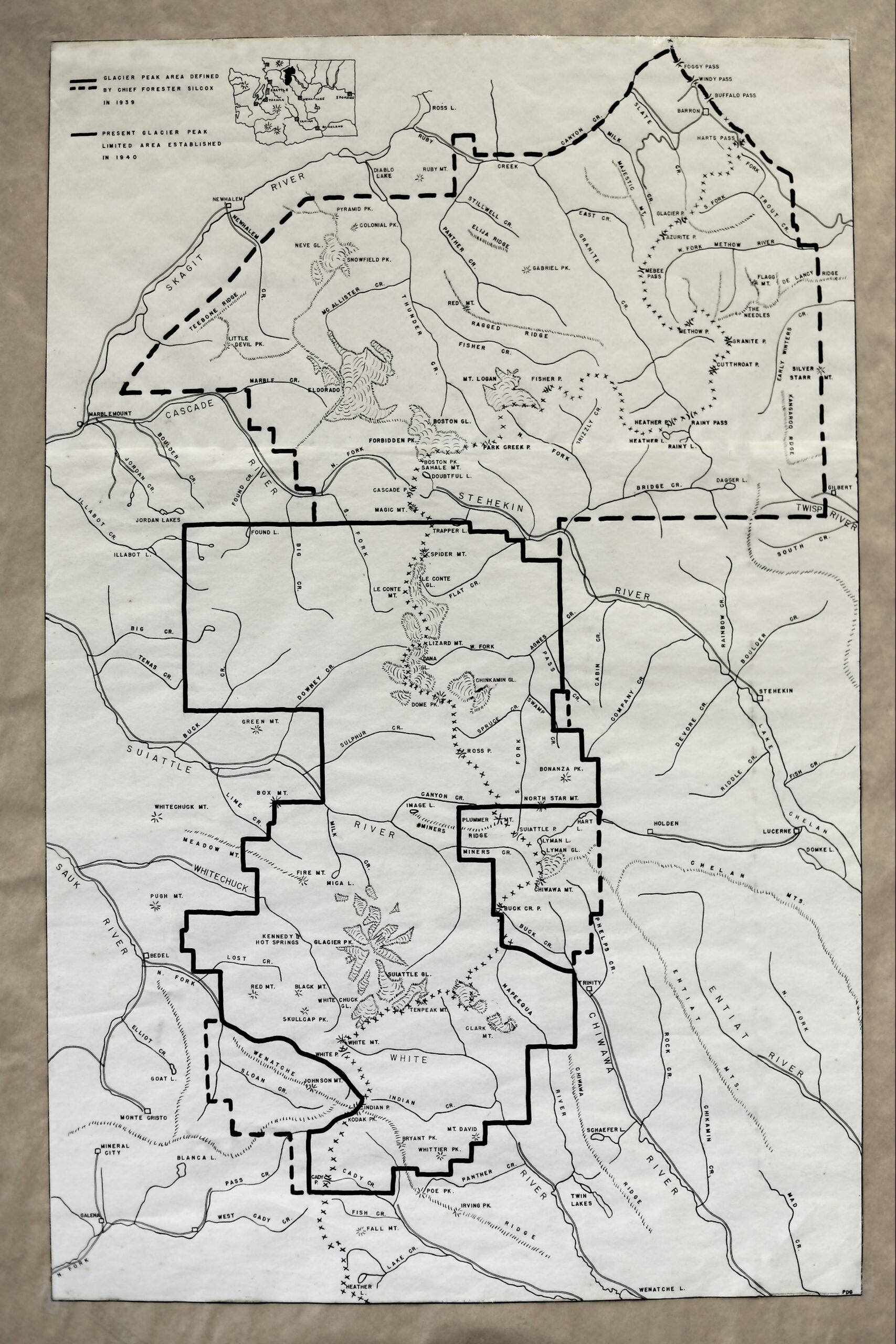
A comparison map drawn by Patrick Goldsworthy ca. 1958, alerting the public to the huge reduction in size of Glacier Peak Wilderness as of 1940. The need to expand this protected area back at least to its previous boundaries was a major motivation behind the founding of NCCC.
It compares the then-current and relatively small USFS “Glacier Peak Limited Area” of 1940 (solid lines) to the larger 1939 “Glacier Peak Area defined by Chief Forester Silcox” (who died in 1939) (dashed lines), which included what is now the south unit of North Cascades National Park and several more low valleys of ancient forest.
Hand drawn on vellum, probably one of the first maps Dr. Goldsworthy drew about the time NCCC was founded in 1957. Note the lack of a North Cascades Highway.
This map is featured in National Geographic’s Atlas of Wild America.
Skagit River Watershed
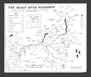
Prepared as part of the booklet “From the Mountains to the Sea” in 1991, Jon Riedel, National Park Service Geologist used existing USGS maps to produce this overview map showing the full watershed of the Skagit River that drains much of the northern portion of the west side of the North Cascades, from Canadian headwaters to the Salish Sea.
Glacier Peak Open Pit Mine:
A Disaster Averted by Citizen Action
Read Harvey Manning’s Wilderness Alps about how NCCC successfully stopped the proposed open pit mine on Miners Ridge near Image Lake, despite the mining company having the legal right to despoil the landscape under a 20 year mining exception to the Wilderness Act. Here’s a map by Patrick Goldsworthy of where that mine and it’s associated mill and road would have been, if it weren’t for NCCC. Our logo is of the view from Image Lake, known as a scenic highlight of the North Cascades and the nation.

Keep this in mind next time you hike there to the quiet, wild heart of the North Cascades. And if you go to Holden, directly east of this, take a look at the damage created by the mine there – and remember that Holden mine wasn’t an open pit!
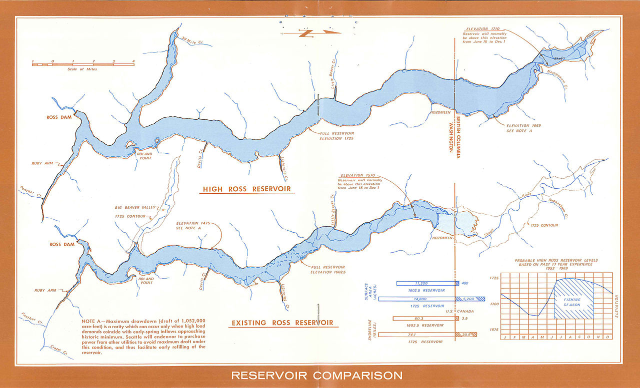
Ross Reservior Size Comparison Maps
Map depicts the expanded footprint of a raised Ross Reservoir if Seattle City Light had built High Ross Dam. (More background is here.) NCCC campaigned for years to stop the raising of Ross Dam because it would have flooded some of the most unique forests in the country, the ancient cedar groves of the Big Beaver valley. Canadian conservations also opposed it because it would have flooded the upper Skagit River valley in Canada. Ultimately, Canada signed a treaty with Seattle to provide the power that High Ross would have produced, and saved these locations for at least the 80 year term of the treaty.